|
|
|
|
|||||
|
Apuan Alps Regional Park a Geopark in Tuscany |
|||||
|
|
|||||
 |
|||||
|
how to find us The Apuan Alps are easily accessible through national and regional road networks running along the coast, the Magra basin and the river Serchio. Road communication between the two opposing mountainsides is provided by provincial roads linking the city of Massa to the town of Arni of Stazzema and the town of Seravezza with the Garfagnana area through Galleria del Cipollaio (Cipollaio Tunnel). The two provincial roads connecting it to the coast join in the Tre Fiumi area and lead to Castelnuovo Garfagnana through the Tùrrite Secca valley. The coastal mountainside of the Apuan Alps can be reached by car through the A12 Genova-Livorno motorway from the toll gates of Carrara, Massa, Versilia and Viareggio, whereas the inner mountainside can be reached through A15 Parma-La Spezia motorway (Aulla toll gate) or through A11 Firenze mare from Lucca toll gate. By train, the main stations of Carrara, Massa, Forte dei Marmi, Pietrasanta and Viareggio are accessible by the Genova-Livorno railway line. Another option is travelling along the inner mountainside in the areas of Garfagnana and Lunigiana with local trains from Lucca to Aulla stopping at a numerous small stations (including Bagni di Lucca, Barga-Gallicano, Castelnuovo Garfagnana, Camporgiano, Piazza al Serchio, Minucciano-Casola, Equi Terme, Rometta-Fivizzano, etc.). Moreover, the numerous villages of the Apuan Alps are linked to the main centres of Massa, Carrara, Lucca and Viareggio through various public bus lines. By plane, the nearest airport is Galileo Galilei Airport in Pisa. |
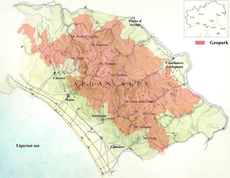
Apuan Geopark: surface area and geographic and human elements The area proposed for the membership in the European and Globa Geoparks Networks coincides with the territory of competence of the Apuan Alps Regional Park. Zonation was established by the map annex to Tuscany Regional Law no. 65/1997 and can only be modified as regards the surface area with the Plan for the Park only, on the initiative of the Authority managing the protected area following the approval by the Tuscan regional administration. The surface area proposed as Geopark totals 493.87 km2, 205.98 km2 of which is the Park area, 271.07 km2 of protected surrounding areas and 16.82 km2 nearby area for mining activities (“adjacent quarry area”). The candidate territory is situated within the administrative borders of 19 municipalities and it is entirely included in the provinces of Lucca and Massa Carrara which belong to the Region of Tuscany. There are fourteen municipalities within the province of Lucca: Camaiore, Camporgiano, Careggine, Castelnuovo di Garfagnana, Fabbriche di Vergemoli, Gallicano, Minucciano, Molazzana, Pescaglia, Piazza al Serchio, Seravezza, Stazzema and Vagli Sotto, for a total of 338.04 km2. There are six municipalities within the province of Massa Carrara: Carrara, Casola in Lunigiana, Fivizzano, Fosdinovo, Massa and Montignoso, for a total of 155.83 km2. According to the most recent estimate, the population of the Geopark area amounts to 16,150 inhabitants, 742 of whom live within the Park and 15,408 in the surrounding areas. Overall, the average population density is 32.7 inhabitants/km2, of which 3,6 inhabitants/km2 in the Park area and 53,5 in the surrounding areas.
|
||||
|
Documents for the admission at EGN
of the Apuan Alps Regional Park 24th-27th June 2011 - Evaluation Mission 15th March 2011 - Application Dossier II 26th November 2010 - Application Dossier I
the
documents are recorded in
|
|
||||