|
download:
trail leaflet
geosite inventory card
|
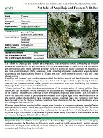
Anguillaja
and
Fatonero
are
two
ditchs of the
Apuan
Alps,
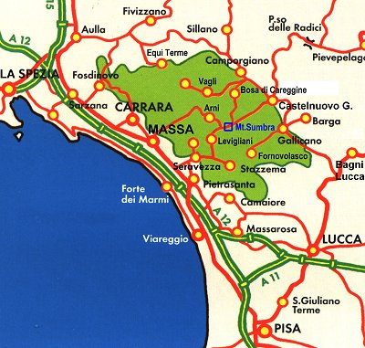
located in the southern slopes of Mt. Sumbra (1765 m) and
Mt.
Fiocca
(1709
m) in part,
about
650
m away
from each other.
Both
ditches
are
left tributaries
of the Turrite
Secca
stream, which in turn is
right
tributary
of the
Serchio river.
Here,
the
channelled
swirling
waters
have
dug
in
their
rock
bed
spectacular
largecavity-shaped
pot,
better
known
as
the
Giants'
pot-holes.
They
are
presented
to the viewer as
regular
cavities,
roughly
circular
in shape,
with
very
smooth
walls
and a
cap shaped bottom mostly.
Anguillaja and
Fatonero’s pot-holes
are naturally
carved
into
the rock and
their size
is
extremely variable,
ranging from
a few
centimetres
in diameter
up
to
6.6
m, and the depth
of
1.6
m.
|

Two Giants' pot-holes
in the Fatonero ditch
|
|
|
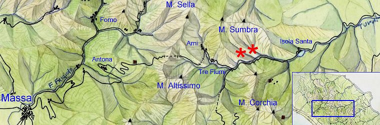
How to find us
From
Lucca:
follow the Serchio river along the valley road. After 48 km you will
reach Castelnuovo Garfagnana. Then take the provincial road n. 13 in the
direction of Forte dei Marmi/Versilia for a total of 60 km.
From Massa: exit the A12 motorway at Massa and follow the signs
for Antona. The provincial road n. 4 reaches Pian della Fioba and
crosses the Apuan ridge at the tunnel called "Passo del Vestito". After
the second tunnel is Arni. At the end of this road, turn left onto the
road coming from Versilia (SP 13). Continue in the direction of
Garfagnana for almost 1 km, for a total of 35 km.
From Versilia: exit the A12 motorway at Versilia and follow the
signs for Castelnuovo Garfagnana. After Seravezza, take the provincial
road (n. 9 e 10) that passes through Ruosina, Retignano, Levigliani and
Terrinca. Then go through the Cipollaio tunnel and cross the road coming
from Massa. From here, the route is the same as above, for a total of 28
km.
|