Apuan Alps Geopark
how to find us
The Antro del Corchia's tourist Caves
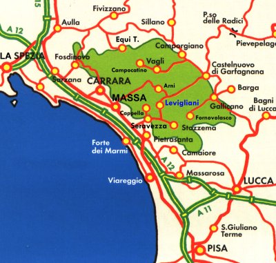
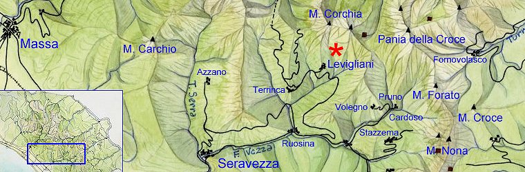
are located in Levigliani of Stazzema (Lucca)
The village of Levigliani is situated at the edge of the Apuan Alps
Regional Park, in the Versilia hinterland, at about 600 mt above sea
level.
It is easily reachable by car following the provincial road of Arni through the village of Seravezza, Ruosina and Retignano, or through
Castelnuovo Garfagnana.
Levigliani is 24 km far from Massa, 29 far from
Viareggio, 32 far from Castelnuovo Garfagnana, 48 far from Lucca, 57 far
from Pisa:
-
Tollgate Versilia A12 (E80) Genova-Rosignano: 20 km far
-
Rail Station FF.SS. Forte dei Marmi-Querceta: 16 km far
-
Airport Galileo Galilei, Pisa: 61 km far
-
Bus service: Vaibus
opening times
tickets prices
Ticket Office Information
c/o reception of Museum
via IV Novembre, 70
55040 Levigliani di Stazzema (Lucca)
tel. +039 0584 778405
fax +039 0584 778053
For
more information:
on the Antro del Corchia's tourist Caves and other
structures of "Corchia Underground" System:
Apuan itineraries
Antro Corchia
karst complex
(tourist routes)
The importance of Antro del Corchia’s karst
Complex transcend the national level, especially with regards to absolute
value of its dimensions, measured both in length (about 53 km) and deepness
(1187 m), and the historical contribution of the site to the development of
speleological exploration.
|
Visit to underground route |
|
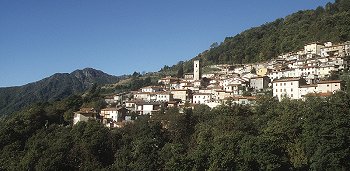
Levigliani is a small village situated on an orographic
terrace, at 600 m of altitude, at the bottom of the lofty towering
walls characterising the southern side of the Mount Corchia (1678
m).
If you get to Levigliani by your own transport, you can leave your
car or motorbike in one of the two parking places situated both at
the beginning and at the end of the village.
|
 |
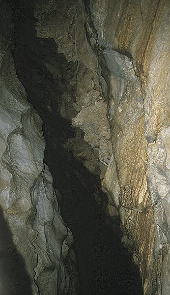 |
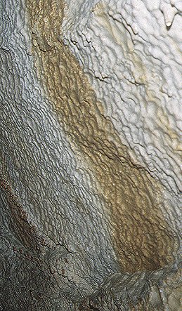
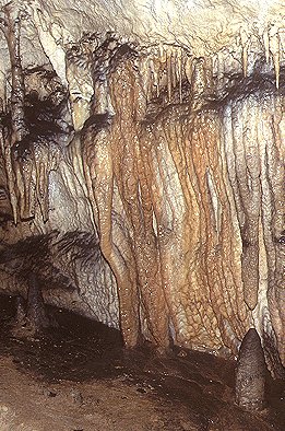
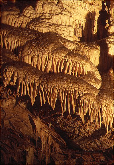
You can reach it in few minutes and after some sharp turns, following a marble-road, going up to the altitude of 860 m. This service is included in the admission fee. The artificial entrance of the Corchia’s cave is situated inside an old quarry. The connection gallery looks like the natural subterranean continuation of the external front of the quarry itself. The route goes on slightly uphill for about 170 m in length, getting over a difference in height of about 20 m. The depth of the artificial duct is not fully perceivable because of the presence of a sequence of three doors dividing as many stretches of the gallery, and closing it “air tight”. The aim is that of controlling the draught exchanges between the inside and the outside environment. As you enter the karst cave, you immediately enjoy, on your right, the sight of a squat conoidal stalagmitic concretion called “The gendarme”. Your progression inside the cave is now made easier by the presence of gangways in the shape of bridges, flights and large steps. Avoiding the contact with the bottom of the cave, they have moderated the transformation of the karst system, caused by the presence of tourists. Through a difference in height of 37 m and the presence of 212 steps, the route develops in a difficult descent down the so-called “Galleria Franosa” (the Landslides Gallery), whose middle stretch is made of a single stunning and narrow space. This is over 30 m high and never larger than 4 m, even though it can shrink to 150 cm. The spot, originated from a large vertical fracture, is characterised by walls, that, nowadays, are fairly wavy, and present, here and there, large and deep sub-horizontal engravings. The so-called “Galleria Franosa” (the Landslides Gallery) ends at an height of 843 m., in a widening characterised by deposits of masses on the vault. Here is the starting point of the so-called “Galleria degli Inglesi” (the English Gallery) and that of the way in to the so-called “Pozzo Suzanne” (the Shaft Suzanne). |
|
The equipped stretch of the “English Gallery” is 245 m long. It is
part of a network of straight, horizontal and overlapping ducts
originated on the layer of a single sub-vertical fracture. This
underwent to a subsequent enlargement caused by chemical and
mechanical phenomena. The two main galleries are divided, even
though many points of connection are present along the route. These
vertical links are more evident after the middle of the route, where
the cave’s vault rises as far as the higher ducts. Right here the
English Gallery is interrupted by small drops made of blocks fallen
down to the ground. |
 |
 |
After about 75 m., the route reaches the
so-called “Laghetto del Venerdì” (the Friday Small Lake). Here the
waters are not very deep even though they are crossable only with
the help of a bridge grounded on the opposite sandy shore. This
little spot has always been a camp frequented by speleologists; at
least so it seems judging by the countless overlapping writings on
the walls. The route reaches a narrow and steep gorge. Here flows
the water of a small stream, which keeps going right, inside the
so-called “Pozzo della Gronda” (the Gronda’s Shaft) (also known as
“Pozzo della Cascata” - the Waterfall Shaft). There has its origin
that long sloping branch of the Corchia’s cave, which ends at the
cave’s bottom, at about 450 m of height. |
|
At
the deepest point of the Corchia’s cave, the walls ooze with the damp
coming from the active phreatic levels situated further. |
 |
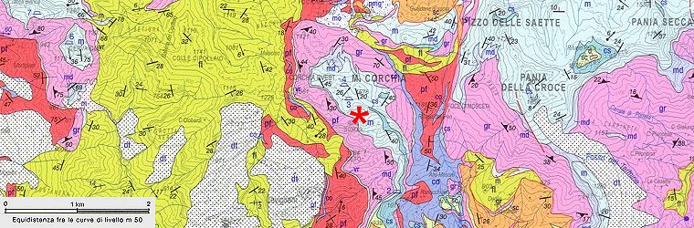
geographic location:
geological map:
sei il visitatore n.
dal 1° luglio 2009